
- This event has passed.
🏔️ PNOA Tricouni Berg Lake Trail Day Hike 🏔️
June 8 @ 9:00 am – 4:00 pm PDT
Leader
Patrick Ni
INFO@PNOA.CA
📍 Location / 地点:
Squamish-Lillooet Regional District, north of Squamish, BC – Backcountry route toward Berg Lake near Tricouni Peak
不列颠哥伦比亚省斯阔米什北部偏远山区,通往 Tricouni 峰附近的 Berg Lake
🚗 Trailhead / 步道起点:
End of a forest service road (FSR) off Squamish Valley Road – gravel road access, not a numbered highway
从 Squamish Valley Road 转入森林服务道路(FSR)的尽头 – 碎石路,非主干公路
📅 Dates (updated) / 日期: June 8, 2026 | 2026年6月8日
👤 Leader in Charge / 领队: Patrick Ni
👥 Max Participants / 最多参与人数: 8
✅ Requirements / 参与要求
- Cardio endurance: Hike 8–12+ km with 400–600m+ elevation gain comfortably
有氧耐力: 能轻松完成 8–12+ 公里、爬升 400–600+ 米 - Strong legs & core for rooty/rocky climbs
腿部和核心力量强,能应对树根和岩石地形 - Balance & stability on uneven, muddy, or snowy trails
平衡与稳定能力,适应不平、泥泞或雪地路面 - For June (early season): Expect mud, slush, possible snow/ice at higher elevations – Microspikes + trekking poles often needed
6月初(季初):泥泞、雪泥、高海拔可能有雪/冰 – 通常需要微钉冰爪 + 登山杖
💪 Recommended Profile / 推荐参与者条件
- Regular hiker, moderate-to-good shape
规律徒步者,体能中上 - No major joint, heart, or lung issues
无严重关节、心脏或肺部问题 - Comfortable carrying a 5–8 kg daypack
能轻松背负 5–8 公斤日背包
🎯 Bottom line / 核心说明:
If you regularly do similar or harder hikes → you’ll be fine. Beginners or low-fitness hikers may struggle – train with hill hikes for weeks beforehand. Always check recent trail conditions.
如果你经常进行类似或更难级别的徒步 → 没问题。新手或体能偏低者可能会吃力 – 请提前几周进行爬坡训练。出发前务必查看最新步道状况。
🗺️ Itinerary (subject to weather) / 行程安排(根据天气可能调整)
Trail length / 步道长度: ~12 km out & back / 约12公里往返
Cumulative elevation gain / 累计爬升: 558 m
Elevation / 海拔: 1509 m
Trailhead elevation / 步道起点海拔: 1367 m
Net elevation gain / 净爬升: 142 m
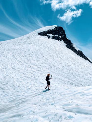
A steep, challenging backcountry route. Climbs steadily through forest to Berg Lake, a small alpine lake below Tricouni Peak. In early June: expect mud, slush, possible snow – ungroomed, unmaintained. Best for experienced hikers with strong fitness, navigation, and proper gear.
这是一条陡峭、有挑战性的偏远山径。持续爬升穿越森林,抵达 Tricouni 峰下的小型高山湖 Berg Lake。6月初可能遇到泥泞、雪泥和积雪 – 无维护步道。适合体能强、有导航经验及合适装备的进阶徒步者。
⏰ Meeting & Timing / 集合与时间
📌 Meeting Location / 集合地点:
GPS: 49.9758900, -123.2215900
Google Maps / 谷歌地图链接:
https://maps.app.goo.gl/2b4fnX97idqCHmA78
⏱️ Meeting time / 集合时间: 9:00 AM (FYI – leader leaves home before 6:15 AM / 供参考:领队 6:15 AM 前出门)
🚶 Starting time / 上山开始时间: 9:15 AM
🏁 End time / 结束时间: 4:00 PM
☀️ Weather Forecast (check again later) / 天气预报(出发前请复核)
Sunny 7 – 15°C ☀️
https://www.mountain-forecast.com/peaks/Tricouni-Peak/forecasts/2122
🎯 Event Objectives / 活动目标
- Enjoy the beautiful mountain views and explore the alpine
欣赏壮丽山景,探索高山风光 🏞️ - Enhance safety awareness for outdoor activities
提升户外活动安全意识 ⚠️
📧 More Info / 更多信息
Email / 电邮: INFO@PNOA.CA
👉 Ready to join? Make sure you meet the requirements and check recent trail conditions before heading out!
👉 准备参加?请确保符合要求,并在出发前查看最新步道状况!
- 🥾 Hiking boots & spikes 登山鞋及冰爪
- 🎒 Hiking backpack 登山背包
- 🌧️ Water-proof clothes 防水衣物
- 💧 Water 饮用水
- 🧴 Sunscreen 防晒用品
- 📱 Cell phone or camera 手机或相机
- 📢 Whistle 哨子
- 🍫 Energy bars / drinks 能量棒或能量饮料
- 🔋 Battery pack 充电宝
- 🥢 Hiking poles 登山杖
- 🐻 Bear bell / bear spray 熊铃或防熊喷雾
- 📻 Walkie-talkie 对讲机
- 🔦 Headlight or flashlight 头灯或手电筒
- 🦵 Gaiters 雪套
- ⛑️ First-aid pack 急救包
- 🆘 Emergency rescue blanket 紧急保温毯
- 🗺️ Offline maps 离线地图:Maps.ME / AllTrails App etc.